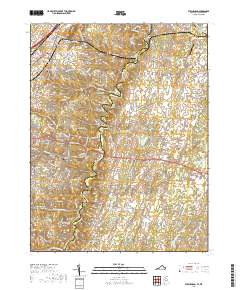
2019 Map of Stephenson
USGS Topo · Published 2019About this map
Opequon Creek meanders through the heart of this landscape, separating the developing residential clusters of Shenandoah Hills and Greenwood Heights from the older rural crossroads to the east. The terrain is defined by geological features such as the Devils Backbone ridge and the water network including Redbud Run and Abrams Cr. Many small family and church burial grounds are scattered throughout the area, including Old Salem Cem, Stones Chapel Cem, and Jabbers Hill Cem, providing significant points of interest for genealogists tracking early settlers.
Find a feature on this map
157 named features on this map. Tap any name to fly to it.
Don’t see what you’re looking for? This feature index may not catch every label — zoom into the map to look around manually.
Map Details
Editions of this 2019 Stephenson Map
This is the sole edition of this map. No revisions or reprints were ever made.
Other maps of this area

1884 · Harpers Ferry
USGS Topo · 1:125,000

1891 · Harpers Ferry
USGS Topo · 1:125,000

1893 · Harpers Ferry
USGS Topo · 1:125,000

1894 · Winchester
USGS Topo · 1:125,000

1914 · Martinsburg
USGS Topo · 1:48,000

1914 · Gerrardstown
USGS Topo · 1:48,000

1916 · Gerrardstown
USGS Topo · 1:62,500

1916 · Martinsburg
USGS Topo · 1:62,500

1916 · Berryville
USGS Topo · 1:62,500

1937 · Gerrardstown
USGS Topo · 1:48,000