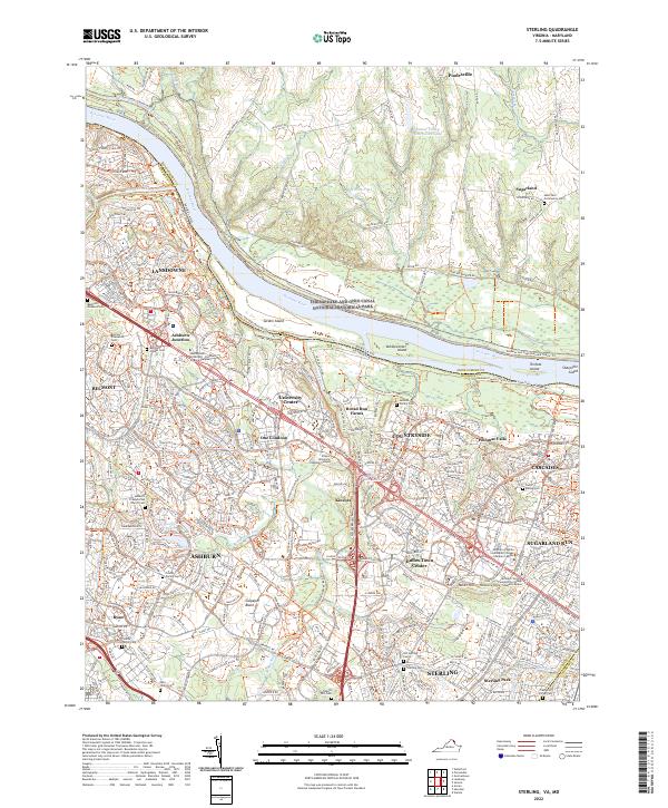
2022 Map of Sterling
USGS Topo · Published 2022About this map
The Potomac River defines the northern boundary of this detailed look at suburban growth along the Virginia-Maryland border, where modern developments like One Loudoun and Dulles Town Center coexist with significant sites of local history. The map documents the extensive Chesapeake and Ohio Canal National Historical Park winding along the river's northern bank near Poolesville. Of particular note for genealogists and local historians are the numerous small burial grounds and landmarks that predate the modern residential corridors, including the Belmont Plantation, the Belmont Enslaved Cem, and the Old Sterling Cem. These sites, along with family-named plots like the Lyon Family Cem and Graves Family Cem, offer a window into the area's agricultural and social foundations. The terrain is marked by major tributaries like Broad Run and Goose Creek, while the presence of institutions such as the Northern Virginia Community College Loudoun Campus signals the region's contemporary shift into a regional hub of education and commerce.
Find a feature on this map
62 named features on this map. Tap any name to fly to it.
Don’t see what you’re looking for? This feature index may not catch every label — zoom into the map to look around manually.
Map Details
Editions of this 2022 Sterling Map
This is the sole edition of this map. No revisions or reprints were ever made.
Historical Maps of University Center Through Time
4 maps found