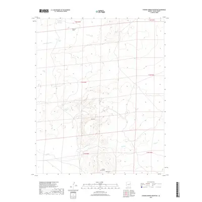
2018 Map of Stinking Springs Mountain
USGS Topo · Published 2018About this map
Stinking Springs Mtn and the adjacent South Mtn rise above a landscape defined by seasonal water management and the meandering path of the Zuñi River. Located in Apache County, this area of Arizona exhibits a pattern of cattle-ranching infrastructure common in the high desert, where named water catchments like Tomahawk Tank, Indian Tank, and Grassy Knoll Tank serve as vital landmarks for navigation and land use. The topography is split by the Seven Springs Wash, which drains toward the north through Surprise Valley. The land is meticulously gridded by township and range lines, reflecting the formal division of the public domain in this corner of the Southwest. Significant elevation changes are marked by North Mtn, providing a stark contrast to the surrounding valley floors.
Find a feature on this map
18 named features on this map. Tap any name to fly to it.
Don’t see what you’re looking for? This feature index may not catch every label — zoom into the map to look around manually.
Map Details
Editions of this 2018 Stinking Springs Mountain Map
This is the sole edition of this map. No revisions or reprints were ever made.
Other maps of this area

1886 · St Johns
USGS Topo · 1:250,000

1892 · St Johns
USGS Topo · 1:250,000

1954 · Saint Johns
USGS Topo · 1:250,000

1955 · Adamana 1 SW
USGS Topo · 1:24,000

1955 · Adamana 4 SW
USGS Topo · 1:24,000

1955 · Adamana 4 NE
USGS Topo · 1:24,000

1955 · Adamana 4 NW
USGS Topo · 1:24,000

1955 · Wolford Springs 3 NW
USGS Topo · 1:24,000

1955 · Adamana 4 SE
USGS Topo · 1:24,000

1955 · Wolford Springs 3 SW
USGS Topo · 1:24,000