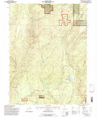
1995 Map of Stirling City
USGS Topo · Published 1997About this map
Stirling City serves as a central hub on this ridge-country map, characterized by a transition from industrial activity to protected forest land. The presence of the Sewage Disposal Ponds and a Landing Strip near the town center reflect its functional layout in the mid-1990s. The landscape is deeply carved by water, with the West Branch Feather River and Butte Creek defining the complex topography of Thatcher Ridge and Carpenter Ridge. Historical infrastructure is visible through the Hendricks Canal and several flumes that once serviced the area's timber or mining needs.
Find a feature on this map
62 named features on this map. Tap any name to fly to it.
Don’t see what you’re looking for? This feature index may not catch every label — zoom into the map to look around manually.
Map Details
Editions of this 1995 Stirling City Map
This is the sole edition of this map. No revisions or reprints were ever made.
Other maps of this area

1886 · Lassen Peak
USGS Topo · 1:250,000

1888 · Bidwell Bar
USGS Topo · 1:125,000

1891 · Bidwell Bar
USGS Topo · 1:125,000

1891 · Chico
USGS Topo · 1:125,000

1892 · Lassen Peak
USGS Topo · 1:250,000

1893 · Chico
USGS Topo · 1:125,000

1893 · Bidwell Bar
USGS Topo · 1:125,000

1894 · Lassen Peak
USGS Topo · 1:250,000

1895 · Bidwell Bar
USGS Topo · 1:125,000

1895 · Chico
USGS Topo · 1:125,000