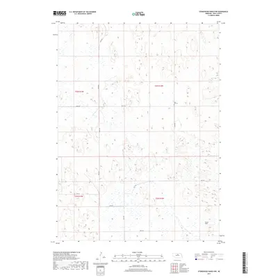
2017 Map of Stonehouse Ranch NW
USGS Topo · Published 2017About this map
The Nebraska Sandhills define the landscape of this Rock County region, where the terrain transitions into the level expanse of Gracie Flats. In a territory where roads follow the strict geometry of the Public Land Survey System, the few established thoroughfares like 450th Ave and 854th Rd provide the primary structural framework for the remote ranchlands. The presence of Rose Hill Cem serves as a lone marker of community history amidst the wide-open township boundaries of t26n r18w and t25n r18w. This 2017 survey by the U.S. Geological Survey documents a modern look at the land's hydrology and small-scale infrastructure, showing how natural drainage and wetlands interact with the gridded county roads that navigate the complex topography.
Find a feature on this map
14 named features on this map. Tap any name to fly to it.
Don’t see what you’re looking for? This feature index may not catch every label — zoom into the map to look around manually.
Map Details
Editions of this 2017 Stonehouse Ranch NW Map
This is the sole edition of this map. No revisions or reprints were ever made.
Other maps of this area

1955 · O'Neill
USGS Topo · 1:250,000

1959 · O'Neill
USGS Topo · 1:250,000

1969 · O'Neill
USGS Topo · 1:250,000

1981 · Stonehouse Ranch NW
USGS Topo · 1:24,000

1981 · Stonehouse Ranch NE
USGS Topo · 1:24,000
1981 · Shovel Dot Ranch
USGS Topo · 1:24,000
1981 · Stonehouse Ranch
USGS Topo · 1:24,000
1981 · Stonehouse Ranch SW
USGS Topo · 1:24,000

1981 · Rose
USGS Topo · 1:24,000

1982 · Stockdale Lake
USGS Topo · 1:24,000