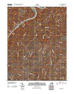
2010 Map of Stonewall
USGS Topo · Published 2010About this map
Stonewall Mills and the nearby village of Stonewall serve as the central points of this 2010 survey of the Appomattox County countryside. The landscape is defined by the winding course of the James River, which divides the terrain and creates landmarks such as Pettyjohn Island. Further inland, the map captures a rural network of small-scale aviation at Skovhus Airport and community anchors like Mount Zion Cemetery and Rebecca Cemetery.
Find a feature on this map
24 named features on this map. Tap any name to fly to it.
Don’t see what you’re looking for? This feature index may not catch every label — zoom into the map to look around manually.
Map Details
Editions of this 2010 Stonewall Map
This is the sole edition of this map. No revisions or reprints were ever made.
Other maps of this area

1892 · Lynchburg
USGS Topo · 1:125,000

1892 · Buckingham
USGS Topo · 1:125,000

1892 · Appomattox
USGS Topo · 1:125,000

1894 · Lexington
USGS Topo · 1:125,000

1935 · Amherst
USGS Topo · 1:48,000

1939 · Amherst
USGS Topo · 1:62,500

1944 · Lynchburg
USGS Topo · 1:62,500

1947 · Roanoke
USGS Topo · 1:250,000

1950 · Amherst
USGS Topo · 1:62,500

1950 · Lynchburg
USGS Topo · 1:62,500