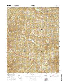
2016 Map of Storck
USGS Topo · Published 2016About this map
Hartwood and Storck serve as central points in this landscape where the boundaries of Stafford, Fauquier, and Culpeper counties converge. The terrain is defined by a dense network of tributaries including Potomac Run, Horsepen Run, and Richland Run which drain toward the Rappahannock River at the southwestern edge. This 2016 survey provides a modern look at a rural region maintaining its historical identity through numerous small family and community burial grounds, such as Briggs-McDonald Family Cem and the Antioch Cem. Small settlements like Glendie, Cropp, and Heflin are interconnected by a web of rural routes and secondary roads, reflecting the persistent settlement patterns of Northern Virginia. Significant landmarks like Curtis Park Lake and Glen Haven Memory Gardens show how contemporary land use integrates with the area’s traditional stream valleys and wooded ridges.
Find a feature on this map
181 named features on this map. Tap any name to fly to it.
Don’t see what you’re looking for? This feature index may not catch every label — zoom into the map to look around manually.
Map Details
Editions of this 2016 Storck Map
This is the sole edition of this map. No revisions or reprints were ever made.
Other maps of this area

1887 · Spottsylvania
USGS Topo · 1:125,000

1889 · Fredericksburg
USGS Topo · 1:125,000

1890 · Mt. Vernon
USGS Topo · 1:125,000

1891 · Mt. Vernon
USGS Topo · 1:125,000

1892 · Fredericksburg
USGS Topo · 1:125,000

1892 · Spottsylvania
USGS Topo · 1:125,000

1894 · Warrenton
USGS Topo · 1:125,000

1894 · Fredericksburg
USGS Topo · 1:125,000

1894 · Mt. Vernon
USGS Topo · 1:125,000

1897 · Mt. Vernon
USGS Topo · 1:125,000