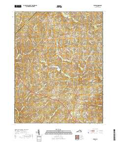
2019 Map of Storck
USGS Topo · Published 2019About this map
Hartwood and Storck anchor this survey of rural Stafford County, where the landscape is defined by the winding drainages of Potomac Run and Long Branch. The area maintains its traditional character, with numerous historical burial grounds such as the Hartwood Presbyterian Church Cem and the Briggs-McDonald Family Cem providing essential data for genealogists tracing local families. The settlement pattern follows established routes through communities like Cropp, Heflin, and Roseville, which are connected by a network of rural roads that cross over Richland Run and Alcott Run. To the east, the residential expansion near Concord and Little Lake Arrowhead contrasts with the preserved open lands and wooded tracts typical of this Piedmont region. This map also captures the local spiritual and social hubs at the Antioch United Methodist Church Cem and Mount Olive Baptist Church Cem.
Find a feature on this map
190 named features on this map. Tap any name to fly to it.
Don’t see what you’re looking for? This feature index may not catch every label — zoom into the map to look around manually.
Map Details
Editions of this 2019 Storck Map
This is the sole edition of this map. No revisions or reprints were ever made.
Other maps of this area

1887 · Spottsylvania
USGS Topo · 1:125,000

1889 · Fredericksburg
USGS Topo · 1:125,000

1890 · Mt. Vernon
USGS Topo · 1:125,000

1891 · Mt. Vernon
USGS Topo · 1:125,000

1892 · Fredericksburg
USGS Topo · 1:125,000

1892 · Spottsylvania
USGS Topo · 1:125,000

1894 · Warrenton
USGS Topo · 1:125,000

1894 · Fredericksburg
USGS Topo · 1:125,000

1894 · Mt. Vernon
USGS Topo · 1:125,000

1897 · Mt. Vernon
USGS Topo · 1:125,000