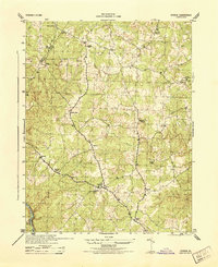
1944 Map of Storck
USGS Topo · Published 1944About this map
Hartwood Church and the nearby Hartwood settlement serve as central landmarks in this rural landscape of Stafford County, surveyed during the height of the Second World War. The map reveals a community defined by crossroads and small gatherings of rural infrastructure, such as the Mt Olive School and the merchant node at Dodds Store. The terrain is deeply dissected by a network of waterways including Aquia Run, Potomac Run, and Long Branch, which dictated the winding paths of secondary roads like those connecting Roseville and Beach. Numerous small congregations are documented here, from Rock Hill Church in the north to Potomac Chapel and Grace Church. Of particular interest to surveyors and historians are the specific geodetic markers, such as USC&GS Hemp 1942 and USC&GS Roseville 1942, which anchored the technical accuracy of this Corps of Engineers production.
Find a feature on this map
26 named features on this map. Tap any name to fly to it.
Don’t see what you’re looking for? This feature index may not catch every label — zoom into the map to look around manually.
Map Details
Editions of this 1944 Storck Map
This is the sole edition of this map. No revisions or reprints were ever made.
Other maps of this area

1887 · Spottsylvania
USGS Topo · 1:125,000

1889 · Fredericksburg
USGS Topo · 1:125,000

1890 · Mt. Vernon
USGS Topo · 1:125,000

1891 · Mt. Vernon
USGS Topo · 1:125,000

1892 · Fredericksburg
USGS Topo · 1:125,000

1892 · Spottsylvania
USGS Topo · 1:125,000

1894 · Warrenton
USGS Topo · 1:125,000

1894 · Fredericksburg
USGS Topo · 1:125,000

1894 · Mt. Vernon
USGS Topo · 1:125,000

1897 · Mt. Vernon
USGS Topo · 1:125,000