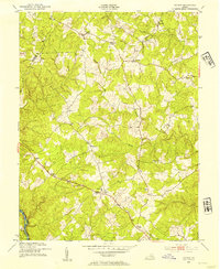
1953 Map of Storck
USGS Topo · Published 1954About this map
The Fauquier and Stafford county lines meet along the southern edge of this mid-century survey, where the Rappahannock River forms a natural border. The landscape is defined by its rural crossroads and small community centers, notably Hartwood with its landmark Hartwood Ch and the neighboring settlement of Hemp. This era captures a decentralized network of rural commerce, represented by Dodds Store and widely dispersed gathering places such as Grace Ch near Heflin.
Find a feature on this map
26 named features on this map. Tap any name to fly to it.
Don’t see what you’re looking for? This feature index may not catch every label — zoom into the map to look around manually.
Map Details
Editions of this 1953 Storck Map
This is the sole edition of this map. No revisions or reprints were ever made.
Other maps of this area

1887 · Spottsylvania
USGS Topo · 1:125,000

1889 · Fredericksburg
USGS Topo · 1:125,000

1890 · Mt. Vernon
USGS Topo · 1:125,000

1891 · Mt. Vernon
USGS Topo · 1:125,000

1892 · Fredericksburg
USGS Topo · 1:125,000

1892 · Spottsylvania
USGS Topo · 1:125,000

1894 · Warrenton
USGS Topo · 1:125,000

1894 · Fredericksburg
USGS Topo · 1:125,000

1894 · Mt. Vernon
USGS Topo · 1:125,000

1897 · Mt. Vernon
USGS Topo · 1:125,000