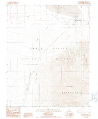
1988 Map of Stovepipe Wells
USGS Topo · Published 1988About this map
Stovepipe Wells serves as a critical desert outpost within the expansive Death Valley National Monument, supporting travelers and residents in one of the most extreme environments in the American West. This 1988 survey details the infrastructure necessary for life in the basin, including a Water Treatment Plant, Sewage Disposal Ponds, and a Trailer Park. The landscape is dominated by the massive Tucki Mountains to the south and the iconic Sand Dunes to the north.
Find a feature on this map
20 named features on this map. Tap any name to fly to it.
Don’t see what you’re looking for? This feature index may not catch every label — zoom into the map to look around manually.
Map Details
Editions of this 1988 Stovepipe Wells Map
This is the sole edition of this map. No revisions or reprints were ever made.
Other maps of this area

1908 · Ballarat
USGS Topo · 1:250,000

1913 · Ballarat
USGS Topo · 1:250,000

1948 · Death Valley
USGS Topo · 1:250,000

1951 · Panamint Butte
USGS Topo · 1:62,500

1951 · Marble Canyon
USGS Topo · 1:62,500

1952 · Stovepipe Wells
USGS Topo · 1:62,500

1952 · Emigrant Canyon
USGS Topo · 1:62,500

1954 · Death Valley
USGS Topo · 1:250,000

1956 · Death Valley
USGS Topo · 1:250,000

1957 · Death Valley
USGS Topo · 1:250,000