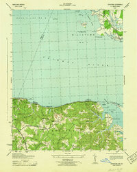
1943 Map of Stratford
USGS Topo · Published 1943About this map
Stratford Hall and the surrounding plantation lands anchor this coastal landscape during the mid-war years, situated along the southern bank of the Potomac River. The terrain is defined by dramatic riverfront features such as the Horsehead Cliffs and Stratford Cliffs, while inland, the area is dissected by numerous waterways including Stratford Mill Run and Kentucky Run. Local settlements like Bryant Town and Lerty are connected by a network of rural roads that trace the high ground between swampy lowlands like Bryant Swamp and Kenna Swamp.
Find a feature on this map
75 named features on this map. Tap any name to fly to it.
Don’t see what you’re looking for? This feature index may not catch every label — zoom into the map to look around manually.
Map Details
Editions of this 1943 Stratford Map
This is the sole edition of this map. No revisions or reprints were ever made.
Other maps of this area

1892 · Leonardtown
USGS Topo · 1:62,500

1892 · Piney Point
USGS Topo · 1:62,500

1892 · Montross
USGS Topo · 1:62,500

1894 · Wicomico
USGS Topo · 1:62,500

1894 · Piney Point
USGS Topo · 1:62,500

1895 · Wicomico
USGS Topo · 1:62,500

1895 · Leonardtown
USGS Topo · 1:62,500

1895 · Nomini
USGS Topo · 1:125,000

1895 · Piney Point
USGS Topo · 1:62,500

1895 · Montross
USGS Topo · 1:62,500