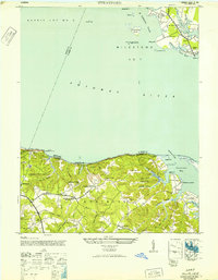
1946 Map of Stratford
USGS Topo · Published 1952About this map
Stratford Hall and the historic plantation lands of the Northern Neck dominate this Potomac shoreline survey. The map records a complex landscape of tidal inlets and deeply incised ravines, where the high ground of Kentucky Hill and Chantilly Hill overlooks the Potomac River. Significant maritime infrastructure is visible along the Maryland shore at River Springs and Colton, while the Virginia side features landmarks such as Mt Airy Wharf and Currioman Landing, reflecting the area's historical dependence on river-borne trade.
Find a feature on this map
74 named features on this map. Tap any name to fly to it.
Don’t see what you’re looking for? This feature index may not catch every label — zoom into the map to look around manually.
Map Details
Editions of this 1946 Stratford Map
This is the sole edition of this map. No revisions or reprints were ever made.
Other maps of this area

1892 · Leonardtown
USGS Topo · 1:62,500

1892 · Piney Point
USGS Topo · 1:62,500

1892 · Montross
USGS Topo · 1:62,500

1894 · Wicomico
USGS Topo · 1:62,500

1894 · Piney Point
USGS Topo · 1:62,500

1895 · Wicomico
USGS Topo · 1:62,500

1895 · Leonardtown
USGS Topo · 1:62,500

1895 · Nomini
USGS Topo · 1:125,000

1895 · Piney Point
USGS Topo · 1:62,500

1895 · Montross
USGS Topo · 1:62,500