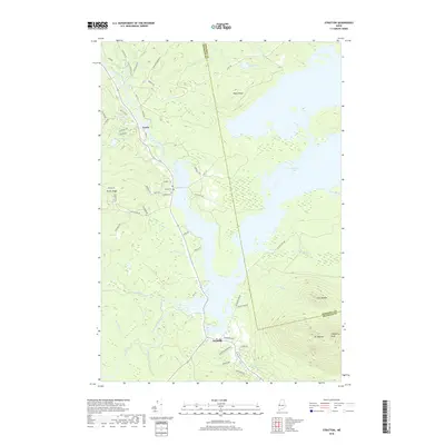
2018 Map of Stratton
USGS Topo · Published 2018About this map
Stratton and Eustis anchor this northern Maine landscape, serving as hubs within a complex network of waterways and ridges. The North Branch Dead River and South Branch Dead River converge near the massive expanse of Flagstaff Lake, which dominates the eastern half of the map. Significant elevations rise to the southeast, where the peaks of Mt Bigelow and Cranberry Peak loom over the basin. Local history is etched into the terrain through sites like Eustis Cem and Flagstaff Cem, while the geography of Eustis Ridge provides a distinct overlook of the surrounding timberlands. Numerous brooks, such as Whiskey Brook, Trout Brook, and Cold Brook, drain from the higher elevations into the lake, illustrating the hydrological connection between the Bigelow Range and the Dead River drainage system.
Find a feature on this map
60 named features on this map. Tap any name to fly to it.
Don’t see what you’re looking for? This feature index may not catch every label — zoom into the map to look around manually.
Map Details
Editions of this 2018 Stratton Map
This is the sole edition of this map. No revisions or reprints were ever made.
Other maps of this area

1928 · Chain Lakes
USGS Topo · 1:48,000

1928 · Spencer
USGS Topo · 1:48,000

1928 · Stratton
USGS Topo · 1:48,000

1932 · Stratton
USGS Topo · 1:62,500

1932 · Kennebago Lake
USGS Topo · 1:48,000

1932 · Spencer
USGS Topo · 1:62,500

1932 · Chain Lakes
USGS Topo · 1:62,500

1935 · Kennebago Lake
USGS Topo · 1:62,500

1935 · Chain Lakes
USGS Topo · 1:62,500

1936 · Kennebago Lake
USGS Topo · 1:62,500