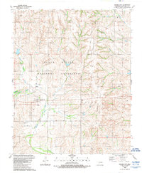
1989 Map of Strong City
USGS Topo · Published 1989About this map
Strong City serves as the focal point of this late-20th-century topographic record, situated near the meandering path of the Washita River in Roger Mills County. The landscape is characterized by the expansive Black Kettle National Grassland and a network of watercourses including Ninemile Creek, Horse Creek, and Caffey Creek. This survey captures a rural environment where industrial activity is indicated by a widespread Gas Field and numerous Gas Well locations, particularly concentrated in the northern townships of Streeter and Dewey.
Find a feature on this map
19 named features on this map. Tap any name to fly to it.
Don’t see what you’re looking for? This feature index may not catch every label — zoom into the map to look around manually.
Map Details
Editions of this 1989 Strong City Map
This is the sole edition of this map. No revisions or reprints were ever made.
Other maps of this area

1955 · Clinton
USGS Topo · 1:250,000

1957 · Clinton
USGS Topo · 1:250,000

1960 · Cheyenne
USGS Topo · 1:62,500

1960 · Hammon
USGS Topo · 1:62,500

1961 · Leedey
USGS Topo · 1:62,500

1966 · Roll
USGS Topo · 1:24,000

1966 · Roll SE
USGS Topo · 1:24,000

1984 · Foss Reservoir
USGS Topo · 1:100,000
1987 · Leedey SW
USGS Topo · 1:24,000

1987 · Big Kiowa Creek
USGS Topo · 1:24,000