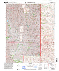
1998 Map of Strong City
USGS Topo · Published 2001About this map
Strong City and its surrounding prairie landscape are defined by the winding course of the Washita River in the heart of Roger Mills Co. This late-twentieth-century revision illustrates the land-use patterns of western Oklahoma, where the vast Black Kettle National Grassland dominates the topography. The map reveals a high density of Gas Wells scattered across the upland plateaus, signaling the region's mid-century energy development alongside traditional ranching. Several waterways, including Dead Indian Creek, Wild Horse Creek, and Coffey Creek, carve through the terrain toward the river valley. Local genealogical interest is anchored by the Strong Cem near the townsite and the Snake Bend Cem located near a sharp oxbow of the river, while several Drill Holes mark the ongoing geological exploration of the era.
Find a feature on this map
15 named features on this map. Tap any name to fly to it.
Don’t see what you’re looking for? This feature index may not catch every label — zoom into the map to look around manually.
Map Details
Editions of this 1998 Strong City Map
This is the sole edition of this map. No revisions or reprints were ever made.
Other maps of this area

1955 · Clinton
USGS Topo · 1:250,000

1957 · Clinton
USGS Topo · 1:250,000

1960 · Cheyenne
USGS Topo · 1:62,500

1960 · Hammon
USGS Topo · 1:62,500

1961 · Leedey
USGS Topo · 1:62,500

1966 · Roll
USGS Topo · 1:24,000

1966 · Roll SE
USGS Topo · 1:24,000

1984 · Foss Reservoir
USGS Topo · 1:100,000
1987 · Leedey SW
USGS Topo · 1:24,000

1987 · Big Kiowa Creek
USGS Topo · 1:24,000