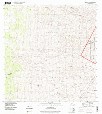
1993 Map of Sulphur Cone
USGS Topo · Published 2001About this map
Sulphur Cone sits atop a landscape defined by the volcanic activity of Mauna Loa, where distinct volcanic events are preserved in the geological record. This survey delineates the massive extent of the Lava Flow of 1949, the Lava Flow of 1950, and the older Lava Flow of 1851 as they descend through the Southwest Rift Zone. The map captures the meeting point of high-altitude districts, showing the intersection of North Kona District and Kau District within the protected boundaries of Hawaii Volcanoes National Park and the Hawaii Volcanoes Wilderness. For the local historian or hiker, the presence of the Old Hawaiian Trail provides a trace of human passage through this desolate terrain of Kohalapilau and the land divisions of Keauhou 2 and Kahuku.
Find a feature on this map
16 named features on this map. Tap any name to fly to it.
Don’t see what you’re looking for? This feature index may not catch every label — zoom into the map to look around manually.
Map Details
Editions of this 1993 Sulphur Cone Map
This is the sole edition of this map. No revisions or reprints were ever made.
Other maps of this area

1927 · Kaohe
USGS Topo · 1:62,500

1928 · Kailua
USGS Topo · 1:62,500

1928 · Mauna Loa
USGS Topo · 1:62,500

1930 · Kaohe
USGS Topo · 1:62,500

1954 · Hawaii South
USGS Topo · 1:250,000

1954 · Hawaii North
USGS Topo · 1:250,000

1956 · Puu O Uo
USGS Topo · 1:24,000
1956 · Kokoolau
USGS Topo · 1:24,000

1959 · Hawaii South
USGS Topo · 1:250,000

1959 · Hawaii North
USGS Topo · 1:250,000