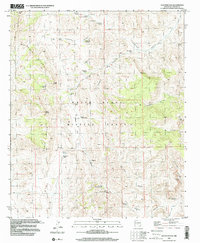
1996 Map of Sulphur Pass
USGS Topo · Published 2001About this map
The White Sands Missile Range dominates this landscape in Sierra County, defining a territory where military activity overlays a network of traditional desert water sources and livestock improvements. The terrain transitions from the high elevations of Big Mountain and the Chalk Hills down into the broad expanse of Sulphur Flats. A reliance on carefully managed water is evident throughout the drainage basins, with named improvements like Rock House Well, DomiJohn Well, and Taylor Tank supporting the arid environment. Local history is etched into the landscape via family or descriptive names such as Crockett Spring and Horse Camp Spring. The area's geological and prospecting history is noted by several Prospects located near the intersection of Sulphur Canyon and El Paso Canyon, reflecting a period when small-scale mining efforts were common in these isolated canyons.
Find a feature on this map
39 named features on this map. Tap any name to fly to it.
Don’t see what you’re looking for? This feature index may not catch every label — zoom into the map to look around manually.
Map Details
Editions of this 1996 Sulphur Pass Map
This is the sole edition of this map. No revisions or reprints were ever made.
Other maps of this area

1916 · Tonuco
USGS Topo · 1:125,000

1916 · Salinas Peak
USGS Topo · 1:125,000

1932 · Tonuco
USGS Topo · 1:125,000

1948 · Sowell
USGS Topo · 1:62,500

1948 · Chicken Well
USGS Topo · 1:62,500

1948 · Kaylor Mountain
USGS Topo · 1:62,500

1948 · Black Top Mountain
USGS Topo · 1:62,500

1954 · Tularosa
USGS Topo · 1:250,000

1955 · Las Cruces
USGS Topo · 1:250,000

1958 · Las Cruces
USGS Topo · 1:250,000