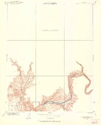
1916 Map of Sulphur Springs
USGS Topo · Published 1960About this map
The San Joaquin River carves a deep path through this 1916 landscape, defining the boundary between Madera and Fresno Counties. Long before the valley was transformed by large-scale water projects, this survey by E.P. Davis records the river's original course and the historic sites along its banks. Notable early landmarks include Old Fort Miller and Old Millerton, remnants of 19th-century settlement along the river corridor.
Find a feature on this map
10 named features on this map. Tap any name to fly to it.
Don’t see what you’re looking for? This feature index may not catch every label — zoom into the map to look around manually.
Map Details
Editions of this 1916 Sulphur Springs Map
2 editions found
Other maps of this area

1912 · Mariposa
USGS Topo · 1:125,000

1916 · Sulphur Springs
USGS Topo · 1:24,000

1919 · Sulphur Springs
USGS Topo · 1:31,680

1919 · Little Table Mountain
USGS Topo · 1:31,680

1922 · Lanes Bridge
USGS Topo · 1:31,680

1922 · Friant
USGS Topo · 1:31,680

1923 · Academy
USGS Topo · 1:31,680

1942 · Raymond
USGS Topo · 1:62,500

1942 · Little Table Mountain
USGS Topo · 1:24,000

1942 · Millerton Lake
USGS Topo · 1:62,500