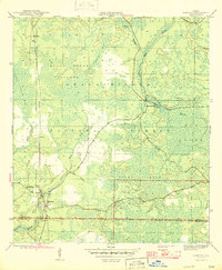
1946 Map of Sumatra
USGS Topo · Published 1946About this map
Sumatra and the small settlement of Bon Ami sit at the western edge of this mid-1940s survey, defined by the industrial corridor of the Apalachicola Northern railroad. The landscape is dominated by the dense wetlands of the Apalachicola National Forest, where drainage patterns like Black Creek and Hog Branch filter into the New River and the isolated Boatwright Lakes. The southern portion of the map transition into the expansive Boggy Jordan and Mud Swamp, revealing the difficult terrain that shaped early transportation and timber activity in this part of Liberty and Franklin Counties. Researchers can locate the Sumatra Firetower and a small Cem near the town center, providing specific points of interest for genealogists and local historians studying the rural development of the Florida Panhandle before modern highway expansion.
Find a feature on this map
19 named features on this map. Tap any name to fly to it.
Don’t see what you’re looking for? This feature index may not catch every label — zoom into the map to look around manually.
Map Details
Editions of this 1946 Sumatra Map
3 editions found
Other maps of this area

1944 · Forbes Island
USGS Topo · 1:24,000

1944 · Queens Bay
USGS Topo · 1:24,000

1945 · Forbes Island
USGS Topo · 1:31,680

1945 · Kennedy Creek
USGS Topo · 1:31,680

1945 · Tates Hell Swamp
USGS Topo · 1:31,680

1945 · Orange
USGS Topo · 1:31,680

1945 · Fort Gadsden
USGS Topo · 1:31,680

1946 · Queens Bay
USGS Topo · 1:31,680

1946 · Sumatra
USGS Topo · 1:31,680

1946 · Owens Bridge
USGS Topo · 1:31,680