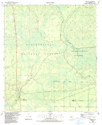
1990 Map of Sumatra
USGS Topo · Published 1990About this map
Sumatra serves as the primary hub of activity in this section of the Florida Panhandle, situated along the Liberty and Franklin County line. The landscape is dominated by the dense wetlands of the Apalachicola National Forest, where intricate drainage systems like Black Creek and Bear Creek move through the Black Islands. To the east, the environment shifts toward the protected Mud Swamp-New River Wilderness, a region characterized by its lack of infrastructure and the winding course of the New River. Small-scale human markers such as the Sumatra Cemetery and a local Sandpit indicate the proximity of local industry and community history within the larger expanse of the Boggy Jordan National Forest. This 1990 survey reflects a period of established conservation, showing the clear boundaries between managed forest lands and designated wilderness areas.
Find a feature on this map
25 named features on this map. Tap any name to fly to it.
Don’t see what you’re looking for? This feature index may not catch every label — zoom into the map to look around manually.
Map Details
Editions of this 1990 Sumatra Map
2 editions found
Other maps of this area

1944 · Forbes Island
USGS Topo · 1:24,000

1944 · Queens Bay
USGS Topo · 1:24,000

1945 · Forbes Island
USGS Topo · 1:31,680

1945 · Kennedy Creek
USGS Topo · 1:31,680

1945 · Tates Hell Swamp
USGS Topo · 1:31,680

1945 · Orange
USGS Topo · 1:31,680

1945 · Fort Gadsden
USGS Topo · 1:31,680

1946 · Queens Bay
USGS Topo · 1:31,680

1946 · Sumatra
USGS Topo · 1:31,680

1946 · Owens Bridge
USGS Topo · 1:31,680