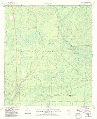
1990 Map of Sumatra
USGS Topo · Published 1990About this map
Sumatra and the small settlement of Bon Ami anchor this 1990 survey of the Florida panhandle's interior wetlands. Located along the boundary of Liberty and Franklin counties, the landscape is dominated by the dense hydrological network of the Apalachicola National Forest. The map documents a complex system of drainage and wetlands, including the Mud Swamp-New River Wilderness and the Black Creek Islands, where waterways like Bear Creek, Little Owl Creek, and Rowletts Creek weave through the forest floor. Local history and genealogy interests are centered on the Sumatra Cem and various landmark sites such as the Radio Tower and local Sandpit locations. The map illustrates the specialized land use of the era, where primitive 4 WD roads provide the primary access into the deep Mud Swamp and the Boggy Jordan area, highlighting the balance between rural settlement and protected wilderness.
Find a feature on this map
22 named features on this map. Tap any name to fly to it.
Don’t see what you’re looking for? This feature index may not catch every label — zoom into the map to look around manually.
Map Details
Editions of this 1990 Sumatra Map
2 editions found
Other maps of this area

1944 · Forbes Island
USGS Topo · 1:24,000

1944 · Queens Bay
USGS Topo · 1:24,000

1945 · Forbes Island
USGS Topo · 1:31,680

1945 · Kennedy Creek
USGS Topo · 1:31,680

1945 · Tates Hell Swamp
USGS Topo · 1:31,680

1945 · Orange
USGS Topo · 1:31,680

1945 · Fort Gadsden
USGS Topo · 1:31,680

1946 · Queens Bay
USGS Topo · 1:31,680

1946 · Sumatra
USGS Topo · 1:31,680

1946 · Owens Bridge
USGS Topo · 1:31,680