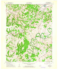
1960 Map of Summit
USGS Topo · Published 1962About this map
The winding Nolin River carves a deep path through southern Hardin County, creating a landscape of sharp loops and isolated points like Pearl Island and Sycamore Island. This 1960 revision captures the rural character of the region as the Illinois Central railroad connects the small settlements of Summit, Eastview, and Stephensburg. Local life is anchored by country churches and schools, including Antioch Ch and Lynnvale Sch, while the terrain is defined by the Bland Knobs and numerous hollows such as Green Rock Hollow.
Find a feature on this map
41 named features on this map. Tap any name to fly to it.
Don’t see what you’re looking for? This feature index may not catch every label — zoom into the map to look around manually.
Map Details
Editions of this 1960 Summit Map
This is the sole edition of this map. No revisions or reprints were ever made.
Other maps of this area

1925 · Cub Run
USGS Topo · 1:62,500

1932 · Big Clifty
USGS Topo · 1:62,500

1934 · Munfordville
USGS Topo · 1:48,000

1935 · Elizabethtown
USGS Topo · 1:48,000

1937 · Munfordville
USGS Topo · 1:62,500

1938 · Elizabethtown
USGS Topo · 1:62,500

1948 · Cecilia
USGS Topo · 1:24,000

1949 · Sonora
USGS Topo · 1:24,000

1949 · Constantine
USGS Topo · 1:24,000

1949 · Summit
USGS Topo · 1:24,000