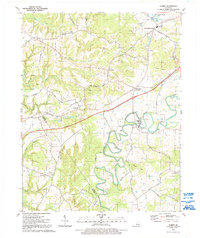
1991 Map of Summit
USGS Topo · Published 1992About this map
The Nolin River winds through the southern reaches of this landscape, its tight oxbows defining the topography near White Mills and Harcourt. This 1991 survey captures a rural Kentucky corridor where long-established farming communities like Summit and Eastview are bisected by the modern Kentucky Parkway. Significant genealogy markers are scattered throughout the hills, including Fairfield Ch, Meeting Creek Ch, and New Hope Ch. North of the river, the terrain rises toward The Hogback and Sand Cave, while industry is represented by a Quarry and scattered Mines. The presence of Old Stephensburg alongside the newer settlement of Stephensburg reflects the shifting centers of local commerce over time, anchored by the Western Kentucky rail line and proximity to the Wonderland Cavern.
Find a feature on this map
60 named features on this map. Tap any name to fly to it.
Don’t see what you’re looking for? This feature index may not catch every label — zoom into the map to look around manually.
Map Details
Editions of this 1991 Summit Map
This is the sole edition of this map. No revisions or reprints were ever made.
Other maps of this area

1925 · Cub Run
USGS Topo · 1:62,500

1932 · Big Clifty
USGS Topo · 1:62,500

1934 · Munfordville
USGS Topo · 1:48,000

1935 · Elizabethtown
USGS Topo · 1:48,000

1937 · Munfordville
USGS Topo · 1:62,500

1938 · Elizabethtown
USGS Topo · 1:62,500

1948 · Cecilia
USGS Topo · 1:24,000

1949 · Sonora
USGS Topo · 1:24,000

1949 · Constantine
USGS Topo · 1:24,000

1949 · Summit
USGS Topo · 1:24,000