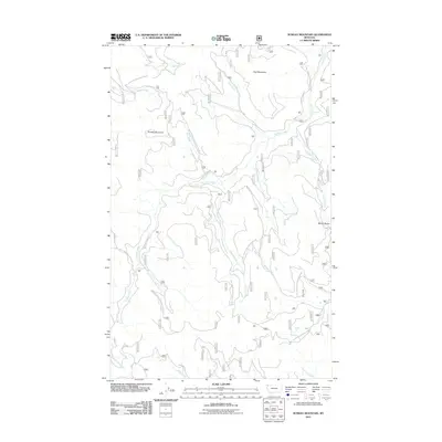
2011 Map of Sunday Mountain
USGS Topo · Published 2011About this map
Paul Mountain and Sunday Mountain anchor this high-elevation landscape in Flathead County, where the terrain is defined by a dense web of forestry access routes. A vast network of United States Forest Service roads, including Natl Forest Develop Road 3711 Rd and the Sunday Creek Rd, traverse the slopes to facilitate timber management and backcountry access. This 2011 survey captures the hydrological complexity of the Stillwater State Forest area, with numerous drainages like Advent Creek, Blessed Creek, and East Fork Sunday Creek carving through the mountains. The presence of the Martin Divide on the eastern edge marks a significant topographical boundary, separating the primary Sunday Creek drainage from the Martin Creek basin. The lack of permanent structures emphasizes the region's role as a managed timber and recreational resource during the early 21st century.
Find a feature on this map
28 named features on this map. Tap any name to fly to it.
Don’t see what you’re looking for? This feature index may not catch every label — zoom into the map to look around manually.
Map Details
Editions of this 2011 Sunday Mountain Map
This is the sole edition of this map. No revisions or reprints were ever made.
Other maps of this area

1913 · Stryker
USGS Topo · 1:125,000

1916 · Stryker
USGS Topo · 1:125,000

1957 · Kalispell
USGS Topo · 1:250,000

1960 · Kalispell
USGS Topo · 1:250,000

1961 · Kalispell
USGS Topo · 1:250,000

1962 · Johnson Peak
USGS Topo · 1:24,000

1963 · Stryker
USGS Topo · 1:24,000
1963 · Skillet Mountain
USGS Topo · 1:24,000

1963 · Sunday Mountain
USGS Topo · 1:24,000
1963 · Edna Mountain
USGS Topo · 1:24,000