
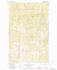
1962 Map of Johnson Peak
USGS Topo · Published 1964About this map
Johnson Peak stands as the central landmark of this section of the Flathead National Forest, crowned by a Lookout Tower that surveys a dense network of mountain drainages. The landscape is defined by the headwaters of numerous streams, including Good Creek, Sanko Creek, and Star Creek, which carve through the high elevations. Transportation in the early 1960s relied heavily on pack trails, such as those crossing Trixie Pass, connecting remote points like Shorts Meadow to the more accessible valley bottoms.
Find a feature on this map
33 named features on this map. Tap any name to fly to it.
Don’t see what you’re looking for? This feature index may not catch every label — zoom into the map to look around manually.
Map Details
Editions of this 1962 Johnson Peak Map
2 editions found
Other maps of this area

1913 · Stryker
USGS Topo · 1:125,000

1916 · Stryker
USGS Topo · 1:125,000

1957 · Kalispell
USGS Topo · 1:250,000

1960 · Kalispell
USGS Topo · 1:250,000

1961 · Kalispell
USGS Topo · 1:250,000

1962 · Lost Creek Divide
USGS Topo · 1:24,000

1962 · Ashley Mountain
USGS Topo · 1:24,000
1962 · Tally Lake
USGS Topo · 1:24,000

1963 · Sylvia Lake
USGS Topo · 1:24,000

1963 · Sunday Mountain
USGS Topo · 1:24,000