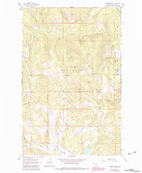
1962 Map of Johnson Peak
USGS Topo · Published 1983About this map
Johnson Peak stands as the central landmark of this mountain landscape within the Flathead National Forest and Stillwater State Forest. A Lookout Tower sits atop the peak, overlooking a network of seasonal drainages and ridges. To the south, the terrain opens into the wetland environment of Star Meadow, where the Star Meadow Guard Station provides a point of human activity amidst the dense topography.
Find a feature on this map
33 named features on this map. Tap any name to fly to it.
Don’t see what you’re looking for? This feature index may not catch every label — zoom into the map to look around manually.
Map Details
Editions of this 1962 Johnson Peak Map
2 editions found
Other maps of this area

1913 · Stryker
USGS Topo · 1:125,000

1916 · Stryker
USGS Topo · 1:125,000

1957 · Kalispell
USGS Topo · 1:250,000

1960 · Kalispell
USGS Topo · 1:250,000

1961 · Kalispell
USGS Topo · 1:250,000

1962 · Johnson Peak
USGS Topo · 1:24,000

1962 · Lost Creek Divide
USGS Topo · 1:24,000

1962 · Ashley Mountain
USGS Topo · 1:24,000
1962 · Tally Lake
USGS Topo · 1:24,000

1963 · Sylvia Lake
USGS Topo · 1:24,000