1911 Map of Sutter
USGS Topo · Published 1911About this map
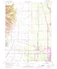
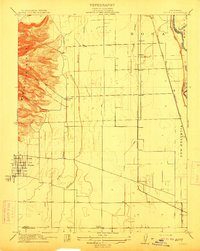
Marysville Buttes dominate the western horizon of this Central Valley landscape, their steep volcanic contours providing a stark contrast to the surveyed grid of the surrounding agricultural lands. In the early twentieth century, the town of Sutter served as a primary hub, organized in a tidy block system south of the heights. The region is defined by a sophisticated water and transit network, including the Southern Pacific and Northern Electric railroads that facilitated the movement of goods and people between rural stops like Nuestro and Stafford. Numerous rural educational centers, including Liveoak School, Union School, and Franklin School, are distributed across the plains, indicating a well-established community of farmstead families. The drainage patterns of Snake Slough and the Little Snake River underscore the low-lying nature of the terrain east of the peaks and west of the Feather River.
Find a feature on this map
31 named features on this map. Tap any name to fly to it.
Don’t see what you’re looking for? This feature index may not catch every label — zoom into the map to look around manually.
Map Details
Editions of this 1911 Sutter Map
This is the sole edition of this map. No revisions or reprints were ever made.
Historical Maps of Yuba City Through Time
6 maps found