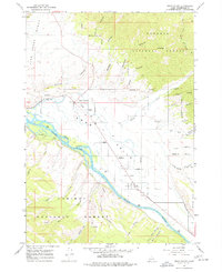
1966 Map of Swan Valley
USGS Topo · Published 1977About this map
The Snake River flows through the heart of the Swan Valley on this 1966 field-checked survey, illustrating a landscape defined by the convergence of the Targhee National Forest and the Caribou National Forest. The small agricultural and mountain settlements of Swan Valley and Irwin are the primary hubs of activity, supported by landmarks like the Ranger Station and rural structures such as the Chapel in the Valley. The terrain is deeply textured by numerous canyons, including Holland Canyon and Oakden Canyon, and high points like Ross Peak and Baldy. Local industry and land use are evidenced by the Gravel Pit near Irwin and various storage bins along the valley floor. Transportation for the era is well-documented through a network of a Jeep Trail, Pack Trail, and the Indian Creek Trail, reflecting the area's role as a gateway for forestry and recreation.
Find a feature on this map
48 named features on this map. Tap any name to fly to it.
Don’t see what you’re looking for? This feature index may not catch every label — zoom into the map to look around manually.
Map Details
Editions of this 1966 Swan Valley Map
Other maps of this area

1932 · Irwin
USGS Topo · 1:96,000

1935 · Irwin
USGS Topo · 1:125,000

1943 · Driggs
USGS Topo · 1:62,500

1943 · Garns Mtn
USGS Topo · 1:62,500

1946 · Driggs
USGS Topo · 1:62,500

1946 · Garns Mtn
USGS Topo · 1:62,500

1955 · Driggs
USGS Topo · 1:250,000

1958 · Driggs
USGS Topo · 1:250,000

1962 · Driggs
USGS Topo · 1:250,000

1966 · Conant Valley
USGS Topo · 1:24,000