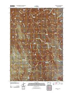
2011 Map of Swede Flat
USGS Topo · Published 2011About this map
Swede Flat and its surrounding high desert landscape are defined by an intricate network of seasonal drainages and vital water sources in this Malheur County survey. The area's livestock and ranching history is evidenced by the numerous named springs such as Horse Camp Spring, Bannock Corral Spring, and Alkali Spring, which serve as critical landmarks in this arid environment. Elevation is punctuated by Burnt Stump Butte, overlooking a series of creek systems including Cottonwood Creek and Rock Cabin Creek. Water management for the region is anchored by the Swede Flat Reservoir and Blue Reservoir. Navigating this remote terrain is facilitated by several named primitive routes, most notably Dry Creek Loop Rd and Cottonwood Mountain Lookout Rd, which provide access to the various forks of Little Willow Creek and the headwaters of Bully Creek.
Find a feature on this map
31 named features on this map. Tap any name to fly to it.
Don’t see what you’re looking for? This feature index may not catch every label — zoom into the map to look around manually.
Map Details
Editions of this 2011 Swede Flat Map
This is the sole edition of this map. No revisions or reprints were ever made.
Other maps of this area

1906 · Mitchell Butte
USGS Topo · 1:125,000

1950 · Jamieson
USGS Topo · 1:62,500

1955 · Baker
USGS Topo · 1:250,000

1955 · Boise
USGS Topo · 1:250,000

1958 · Boise
USGS Topo · 1:250,000

1959 · Baker
USGS Topo · 1:250,000

1962 · Boise
USGS Topo · 1:250,000

1964 · Brogan
USGS Topo · 1:62,500

1966 · Harper
USGS Topo · 1:62,500
1967 · Vines Hill
USGS Topo · 1:24,000