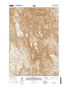
2017 Map of Swede Flat
USGS Topo · Published 2017About this map
Cottonwood Mountain anchors this high-elevation landscape in eastern Oregon, where a complex network of springs and reservoirs supported land use in the late 2010s. The eponymous Swede Flat and its nearby Swede Flat Reservoir are central to the drainage basin, where seasonal water sources like Swede Flat Cr and N G Creek dictate the terrain's character. These labels reveal a history of livestock management and early settlement attempts in Malheur County, evident through names like Bunnock Corral Spring, Rock Cabin Spring Number 1, and Horse Camp Spring. Movement through this area follows established tracks like Dry Creek Loop Rd and the Cottonwood Mtn Lookout Rd, which navigate around distinctive geological features such as Burnt Stump Butte and the various forks of Little Willow Creek Spring.
Find a feature on this map
75 named features on this map. Tap any name to fly to it.
Don’t see what you’re looking for? This feature index may not catch every label — zoom into the map to look around manually.
Map Details
Editions of this 2017 Swede Flat Map
This is the sole edition of this map. No revisions or reprints were ever made.
Other maps of this area

1906 · Mitchell Butte
USGS Topo · 1:125,000

1950 · Jamieson
USGS Topo · 1:62,500

1955 · Baker
USGS Topo · 1:250,000

1955 · Boise
USGS Topo · 1:250,000

1958 · Boise
USGS Topo · 1:250,000

1959 · Baker
USGS Topo · 1:250,000

1962 · Boise
USGS Topo · 1:250,000

1964 · Brogan
USGS Topo · 1:62,500

1966 · Harper
USGS Topo · 1:62,500
1967 · Vines Hill
USGS Topo · 1:24,000