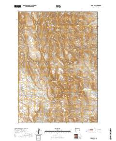
2020 Map of Swede Flat
USGS Topo · Published 2020About this map
Swede Flat anchors this high-desert landscape in eastern Oregon, where a complex system of springs and reservoirs supported ranching and transit through the rugged Malheur County terrain. The naming of features like Burnt Stump Butte and Cottonwood Mountain reflects a geography defined by stark landmarks and vital water sources. A network of primitive roads, including Cottonwood Mtn Lookout Rd and Dry Creek Loop Rd, connects isolated points of interest such as Rock Cabin Spring Number 1 and Bannock Corral Spring. Water management is central to the area's utility, evidenced by the Swede Flat Reservoir and Kern Creek Reservoir, which capture runoff from intermittent streams like Swede Flat Cr. This 2020 survey provides a precise look at the township and range lines that still organize this sparsely populated corner of the state.
Find a feature on this map
36 named features on this map. Tap any name to fly to it.
Don’t see what you’re looking for? This feature index may not catch every label — zoom into the map to look around manually.
Map Details
Editions of this 2020 Swede Flat Map
This is the sole edition of this map. No revisions or reprints were ever made.
Other maps of this area

1906 · Mitchell Butte
USGS Topo · 1:125,000

1950 · Jamieson
USGS Topo · 1:62,500

1955 · Baker
USGS Topo · 1:250,000

1955 · Boise
USGS Topo · 1:250,000

1958 · Boise
USGS Topo · 1:250,000

1959 · Baker
USGS Topo · 1:250,000

1962 · Boise
USGS Topo · 1:250,000

1964 · Brogan
USGS Topo · 1:62,500

1966 · Harper
USGS Topo · 1:62,500
1967 · Vines Hill
USGS Topo · 1:24,000