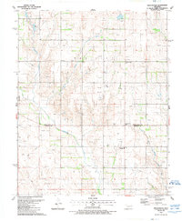
1989 Map of Sweetwater
USGS Topo · Published 1989About this map
Sweetwater serves as the primary hub of this landscape, situated along the county line where Roger Mills Co meets Beckham Co. The town is characterized by its local services, including the Sweetwater High Sch and a nearby Water Tank, which underscore its role as a small rural center in western Oklahoma. The area is intersected by the Texas Oklahoma border, placing these communities at a geographic crossroads defined by agricultural and energy production.
Find a feature on this map
19 named features on this map. Tap any name to fly to it.
Don’t see what you’re looking for? This feature index may not catch every label — zoom into the map to look around manually.
Map Details
Editions of this 1989 Sweetwater Map
This is the sole edition of this map. No revisions or reprints were ever made.
Other maps of this area

1954 · Amarillo
USGS Topo · 1:250,000

1955 · Clinton
USGS Topo · 1:250,000

1957 · Clinton
USGS Topo · 1:250,000

1958 · Amarillo
USGS Topo · 1:250,000

1960 · Sweetwater
USGS Topo · 1:62,500

1961 · Reydon
USGS Topo · 1:62,500

1962 · Kelton SE
USGS Topo · 1:24,000

1963 · Allison
USGS Topo · 1:24,000

1963 · Kelton
USGS Topo · 1:24,000
1982 · Pampa
USGS Topo · 1:100,000