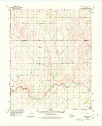
1960 Map of Sweetwater
USGS Topo · Published 1978About this map
The Red River carves a winding path along the southern portion of this landscape, just north of Texola and Delhi. This 1960 survey illustrates the rural development of the Oklahoma-Texas borderlands, centered around the settlement of Sweetwater. Educational and religious foundations are prominent, anchored by the Sweetwater High Sch and several country houses of worship like the Assembly of God Ch and Buffalo Ch.
Find a feature on this map
42 named features on this map. Tap any name to fly to it.
Don’t see what you’re looking for? This feature index may not catch every label — zoom into the map to look around manually.
Map Details
Editions of this 1960 Sweetwater Map
2 editions found
Other maps of this area

1954 · Amarillo
USGS Topo · 1:250,000

1955 · Clinton
USGS Topo · 1:250,000

1957 · Clinton
USGS Topo · 1:250,000

1958 · Amarillo
USGS Topo · 1:250,000

1960 · Sweetwater
USGS Topo · 1:62,500

1960 · Cheyenne
USGS Topo · 1:62,500

1960 · Sayre
USGS Topo · 1:62,500

1961 · Reydon
USGS Topo · 1:62,500

1961 · Willow
USGS Topo · 1:62,500

1961 · Erick
USGS Topo · 1:62,500