1958 Map of Amarillo
USGS Topo · Published 1958About this map
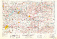
Amarillo Air Force Base and the Pantex Ordnance Plant dominate the military and industrial landscape of the Texas Panhandle in the mid-1950s. This survey illustrates a region defined by its energy and transportation corridors, where the Panhandle and Santa Fe railroad and highways like U.S. 66 link growing oil and gas centers such as Borger, Phillips, and Skellytown. The topography transitions from the Cactus Flats to the broken drainage of the Canadian River and the North Fork Red River.
Find a feature on this map
85 named features on this map. Tap any name to fly to it.
Don’t see what you’re looking for? This feature index may not catch every label — zoom into the map to look around manually.
Map Details
Editions of this 1958 Amarillo Map
This is the sole edition of this map. No revisions or reprints were ever made.
Historical Maps of Amarillo Through Time
3 maps found