
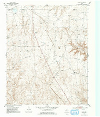
1953 Map of Marsh
USGS Topo · Published 1954About this map
The Panhandle and Santa Fe (At&Sf) Railway cuts a diagonal line across this High Plains landscape, marking the industrial backbone of Potter and Moore Counties in the early 1950s. This survey reveals an era defined by intensive petroleum development, with scores of Gas Wells and an extensive network of Pipe Lines crisscrossing the terrain. The presence of the Fain Compressor Sta underscores the area's role in fuel transport and processing. Beyond the industrial footprint, the natural topography remains prominent, characterized by the prominent John Ray Butte and a complex drainage system including John Ray Creek, Lahey Creek, and Big Canyon. Near the small landing at Marsh, the map illustrates a rugged intersection of natural hydrology and man-made infrastructure typical of the Texas Panhandle's energy-rich ranchlands.
Find a feature on this map
14 named features on this map. Tap any name to fly to it.
Don’t see what you’re looking for? This feature index may not catch every label — zoom into the map to look around manually.
Map Details
Editions of this 1953 Marsh Map
2 editions found
Other maps of this area

1934 · Ady
USGS Topo · 1:62,500

1934 · Cliffside
USGS Topo · 1:62,500

1936 · Fourways
USGS Topo · 1:62,500

1936 · Cliffside
USGS Topo · 1:62,500

1936 · Ady
USGS Topo · 1:62,500

1953 · Chunky
USGS Topo · 1:24,000

1953 · Puente
USGS Topo · 1:24,000

1953 · Masterson
USGS Topo · 1:24,000

1953 · McDowell Creek
USGS Topo · 1:24,000

1953 · Spencer Draw
USGS Topo · 1:24,000