
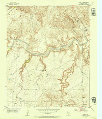
1953 Map of Puente
USGS Topo · Published 1954About this map
The Canadian River carves a deep path through this Panhandle landscape, where high mesas and winding creek beds dictate the placement of ranching outposts. Cattle operations define the local geography, with the Fain Ranch and Cross Bar Ranch serving as focal points for the surrounding drainage systems. These ranches, along with the Fuqua A Bar Ranch to the south, represent the essential livestock economy of Potter County in the early 1950s. Water management is visibly critical, as evidenced by the numerous Windmill sites scattered across the breaks.
Find a feature on this map
21 named features on this map. Tap any name to fly to it.
Don’t see what you’re looking for? This feature index may not catch every label — zoom into the map to look around manually.
Map Details
Editions of this 1953 Puente Map
2 editions found
Other maps of this area

1934 · Ady
USGS Topo · 1:62,500

1934 · Cliffside
USGS Topo · 1:62,500

1936 · Fourways
USGS Topo · 1:62,500

1936 · Cliffside
USGS Topo · 1:62,500

1936 · Ady
USGS Topo · 1:62,500

1953 · Chunky
USGS Topo · 1:24,000

1953 · Marsh
USGS Topo · 1:24,000

1953 · Pleasant Valley
USGS Topo · 1:24,000

1953 · McDowell Creek
USGS Topo · 1:24,000

1953 · Cliffside
USGS Topo · 1:24,000