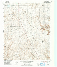
1953 Map of Marsh
USGS Topo · Published 1991About this map
The high plains of the Texas Panhandle are defined here by the industrial footprint of the mid-century energy boom, centered on the Fain Compressor Sta. This 1953 field check reveals an environment where traditional ranching infrastructure, represented by numerous unnamed windmills, coexists with an intensifying network of gas extraction. The landscape is deeply incised by drainages such as Lahey Creek, John Ray Creek, and the prominent Big Canyon, which break the level terrain near the border of Moore and Potter counties. The central landmark of John Ray Butte overlooks a territory shaped by the F W & D Highway, while the settlement at Marsh serves as a small waypoint in this rural industrial corridor. Researchers will find a precise record of early 1950s resource development, including dozens of individual gas wells and the infrastructure required to move fuel from the fields.
Find a feature on this map
12 named features on this map. Tap any name to fly to it.
Don’t see what you’re looking for? This feature index may not catch every label — zoom into the map to look around manually.
Map Details
Editions of this 1953 Marsh Map
2 editions found
Other maps of this area

1934 · Ady
USGS Topo · 1:62,500

1934 · Cliffside
USGS Topo · 1:62,500

1936 · Fourways
USGS Topo · 1:62,500

1936 · Cliffside
USGS Topo · 1:62,500

1936 · Ady
USGS Topo · 1:62,500

1953 · Chunky
USGS Topo · 1:24,000

1953 · Marsh
USGS Topo · 1:24,000

1953 · Puente
USGS Topo · 1:24,000

1953 · Masterson
USGS Topo · 1:24,000

1953 · McDowell Creek
USGS Topo · 1:24,000