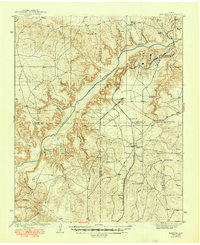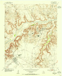
1953 Map of Sanford
USGS Topo · Published 1953About this map
Industrial expansion defines the landscape along the Canadian River in the early 1950s, where the Panhandle's energy boom is etched into the terrain. The region is marked by an intensive network of gas wells and petroleum infrastructure, including multiple instances of the Carbon Black Plant and a dedicated Gasoline Plant. These facilities supported settlements like Sanford and the Combined Camp, while the Chicago Rock Island and Pacific railroad provided the essential transportation link for the Merchant Oil Field.
Find a feature on this map
30 named features on this map. Tap any name to fly to it.
Don’t see what you’re looking for? This feature index may not catch every label — zoom into the map to look around manually.
Map Details
Editions of this 1953 Sanford Map
This is the sole edition of this map. No revisions or reprints were ever made.
Historical Maps of Fritch Through Time
8 maps found