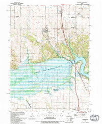
1994 Map of Swisher
USGS Topo · Published 1994About this map
The Iowa River and the sprawling waters of Coralville Lake dominate this Johnson County landscape during the early 1990s. The region is characterized by its extensive protected lands, notably the Hawkeye State Wildlife Area and Swan Lake State Wildlife Area, which follow the meandering river valley. For genealogists and local historians, this survey is exceptionally dense with burial sites, capturing the locations of Western Cem, Anderson Cem, Shueyville Cem, Blain Cem, Dupont Cem, and Greencastle Cem. These cemeteries, often associated with small settlements like Swisher and Shueyville, reveal the nineteenth-century pioneer footprint that remains visible alongside modern infrastructure like the Green Castle Airport. The topography shows the transition from the river's low-lying marshes and ponds, such as Wisniewski Pond, to the more elevated prairie land occupied by the Western community.
Find a feature on this map
33 named features on this map. Tap any name to fly to it.
Don’t see what you’re looking for? This feature index may not catch every label — zoom into the map to look around manually.
Map Details
Editions of this 1994 Swisher Map
This is the sole edition of this map. No revisions or reprints were ever made.
Other maps of this area

1887 · Cedar Rapids
USGS Topo · 1:62,500

1888 · Amana
USGS Topo · 1:62,500

1889 · Amana
USGS Topo · 1:62,500

1891 · Oxford
USGS Topo · 1:62,500

1891 · Cedar Rapids
USGS Topo · 1:62,500

1891 · Iowa City
USGS Topo · 1:62,500

1894 · Oxford
USGS Topo · 1:62,500

1899 · Amana
USGS Topo · 1:62,500

1903 · Fairfax
USGS Topo · 1:125,000

1938 · Iowa City
USGS Topo · 1:62,500