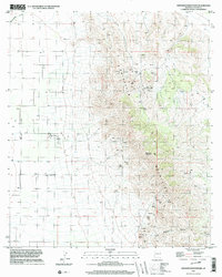
1996 Map of Swisshelm Mountain
USGS Topo · Published 2003About this map
The Swisshelm Mountains dominate this high-desert landscape in Cochise County, defined by a legacy of heavy prospecting and mineral extraction. This study reveals a topography dense with mining infrastructure, ranging from an Open Pit Mine and various Mine Shafts to numerous Adits and Prospects scattered across the elevations. The presence of Usmm 12 suggests a formal mineral monument used for early surveying of these mining claims.
Find a feature on this map
18 named features on this map. Tap any name to fly to it.
Don’t see what you’re looking for? This feature index may not catch every label — zoom into the map to look around manually.
Map Details
Editions of this 1996 Swisshelm Mountain Map
This is the sole edition of this map. No revisions or reprints were ever made.
Other maps of this area

1916 · Pearce
USGS Topo · 1:125,000

1917 · Chiricahua
USGS Topo · 1:125,000

1919 · Chiricahua
USGS Topo · 1:125,000

1922 · Swisshelm
USGS Topo · 1:62,500

1926 · Light
USGS Topo · 1:62,500

1926 · Rucker
USGS Topo · 1:62,500

1926 · Pedregosa
USGS Topo · 1:62,500

1955 · Douglas
USGS Topo · 1:250,000

1958 · Chiricahua Peak
USGS Topo · 1:62,500

1958 · Squaretop Hills
USGS Topo · 1:62,500