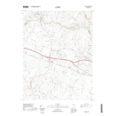
2019 Map of Sykesville
USGS Topo · Published 2019About this map
Sykesville sits at the northern edge of this Piedmont landscape, overlooking the South Branch Patapsco River and the complex county boundaries of Carroll, Howard, and Baltimore. The terrain is defined by the headwaters of several major drainage systems, including the Little Patuxent River and Middle Patuxent River, which carve through the undulating hills of central Maryland. Local history and genealogy are centered around established landmarks like Saint Josephs Ch and Springfield Cem, while the southern reaches of the map show the rural-to-suburban character of West Friendship and Glenelg. The transportation network is anchored by the historic Baltimore-National Pike and Frederick Rd, reflecting the long-standing importance of this corridor for regional travel. Other significant landmarks include the Crestlawn Memorial Gardens and small communities like Henryton and Woodstock, which follow the river valley's natural contours.
Find a feature on this map
31 named features on this map. Tap any name to fly to it.
Don’t see what you’re looking for? This feature index may not catch every label — zoom into the map to look around manually.
Map Details
Editions of this 2019 Sykesville Map
This is the sole edition of this map. No revisions or reprints were ever made.
Other maps of this area

1892 · Laurel
USGS Topo · 1:62,500

1892 · Ellicott
USGS Topo · 1:62,500

1893 · Frederick
USGS Topo · 1:125,000

1894 · Ellicott
USGS Topo · 1:62,500

1894 · Laurel
USGS Topo · 1:62,500

1894 · Frederick
USGS Topo · 1:125,000

1897 · Laurel
USGS Topo · 1:62,500

1906 · Ellicott
USGS Topo · 1:62,500

1907 · Laurel
USGS Topo · 1:62,500

1908 · Patapsco
USGS Topo · 1:125,000