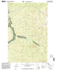
1997 Map of Sylvanite
USGS Topo · Published 2000About this map
The Yaak River corridor defines this remote corner of the Kootenai National Forest, where the settlement of Sylvanite and its corresponding Sylvanite Work Center serve as a focal point for the region's historical activity. The landscape is marked by the extractive heritage of northwestern Montana, evidenced by the Morning Glory Mine and a Gravel Pit located along the river's western banks. A Gaging Station monitors the water flow near the mouth of Fourth of July Creek, highlighting the importance of the river system to local forest management.
Find a feature on this map
30 named features on this map. Tap any name to fly to it.
Don’t see what you’re looking for? This feature index may not catch every label — zoom into the map to look around manually.
Map Details
Editions of this 1997 Sylvanite Map
This is the sole edition of this map. No revisions or reprints were ever made.
Other maps of this area

1957 · Kalispell
USGS Topo · 1:250,000

1960 · Kalispell
USGS Topo · 1:250,000

1961 · Kalispell
USGS Topo · 1:250,000

1963 · Yaak
USGS Topo · 1:24,000

1963 · Turner Mountain
USGS Topo · 1:24,000

1963 · Sylvanite
USGS Topo · 1:24,000

1963 · Mount Baldy
USGS Topo · 1:24,000

1963 · Pulpit Mountain
USGS Topo · 1:24,000
1963 · Newton Mountain
USGS Topo · 1:24,000

1963 · Clark Mountain
USGS Topo · 1:24,000