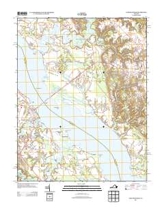
2013 Map of Tappahannock
USGS Topo · Published 2013About this map
The Rappahannock River divides this Tidewater landscape, separating the port of Tappahannock on the west bank from the historic high ground of Warsaw to the east. By the early 21st century, the corridor along Tidewater Trl and Tappahannock Blvd shows the modern commercial footprint of Essex County's seat, while the surrounding lowlands remain defined by their colonial-era heritage and water-bound geography. The map traces a complex network of creeks, including Hoskins Cr and Piscataway Cr, which feed into the river near islands and points like Coleman Island and Lowery Point. On the Richmond County side, the influence of old estates is evident near Smith Hill and the industrial remnants of the Connellee Millpond. The Downing Bridge serves as the primary artery connecting these two historic riverfront hubs, providing a clear view of the transition from dense settlement to the agrarian stretches of Island Farm and Fairview.
Find a feature on this map
55 named features on this map. Tap any name to fly to it.
Don’t see what you’re looking for? This feature index may not catch every label — zoom into the map to look around manually.
Map Details
Editions of this 2013 Tappahannock Map
This is the sole edition of this map. No revisions or reprints were ever made.
Other maps of this area

1892 · Piney Point
USGS Topo · 1:62,500

1892 · Montross
USGS Topo · 1:62,500

1894 · Piney Point
USGS Topo · 1:62,500

1895 · Nomini
USGS Topo · 1:125,000

1895 · Piney Point
USGS Topo · 1:62,500

1895 · Montross
USGS Topo · 1:62,500

1898 · Nomini
USGS Topo · 1:125,000

1901 · Piney Point
USGS Topo · 1:62,500

1917 · Morattico
USGS Topo · 1:62,500

1918 · Tappahannock
USGS Topo · 1:62,500