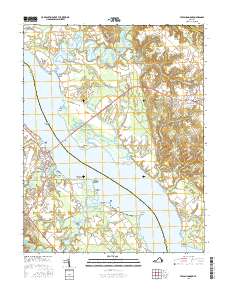
2016 Map of Tappahannock
USGS Topo · Published 2016About this map
Tappahannock and Warsaw anchor this 2016 survey of the Rappahannock River valley, connected by the prominent Downing Bridge crossing. The map reveals a landscape defined by its riparian geometry, where numerous points and bars like Magoright Bar and Lowery Point extend into the broad waterway. This era of the region’s development is characterized by a blend of established riverfront communities like Naylors Beach and institutional growth at the Rappahannock Community Coll Warsaw Campus.
Find a feature on this map
112 named features on this map. Tap any name to fly to it.
Don’t see what you’re looking for? This feature index may not catch every label — zoom into the map to look around manually.
Map Details
Editions of this 2016 Tappahannock Map
This is the sole edition of this map. No revisions or reprints were ever made.
Other maps of this area

1892 · Piney Point
USGS Topo · 1:62,500

1892 · Montross
USGS Topo · 1:62,500

1894 · Piney Point
USGS Topo · 1:62,500

1895 · Nomini
USGS Topo · 1:125,000

1895 · Piney Point
USGS Topo · 1:62,500

1895 · Montross
USGS Topo · 1:62,500

1898 · Nomini
USGS Topo · 1:125,000

1901 · Piney Point
USGS Topo · 1:62,500

1917 · Morattico
USGS Topo · 1:62,500

1918 · Tappahannock
USGS Topo · 1:62,500