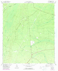
1975 Map of Tarboro
USGS Topo · Published 1987About this map
Tarboro and its surrounding wetlands define this coastal Georgia landscape during the mid-1970s. The settlement is centered near a cluster of community landmarks, including Clinchs Chapel and Brown Chapel, while the local topography is dominated by the vast drainage systems of White Oak Creek and Waverly Swamp. A notable piece of transportation history is visible in the Old Railroad Grade that cuts through the terrain, marking a former corridor through the lowlands. Genealogists will find significant value in the detailed plotting of family-named sites such as Harrell Cem and Bickley Chapel Cem. The map also documents the proximity to Kings Bay, with the interior landscape characterized by numerous flowing wells and the expansive Redcap Swamp. This survey provides a precise record of the rural infrastructure before late-century development, including a Landing Strip and a Lookout Tower positioned for forest surveillance.
Find a feature on this map
20 named features on this map. Tap any name to fly to it.
Don’t see what you’re looking for? This feature index may not catch every label — zoom into the map to look around manually.
Map Details
Editions of this 1975 Tarboro Map
This is the sole edition of this map. No revisions or reprints were ever made.
Other maps of this area

1917 · Nahunta
USGS Topo · 1:62,500

1917 · Boulogne
USGS Topo · 1:62,500

1918 · Nahunta
USGS Topo · 1:62,500

1918 · Bladen
USGS Topo · 1:62,500

1918 · Kingsland
USGS Topo · 1:62,500

1919 · Boulogne
USGS Topo · 1:62,500

1939 · Bladen
USGS Topo · 1:62,500

1946 · Brunswick
USGS Topo · 1:250,000

1948 · Jacksonville
USGS Topo · 1:250,000

1948 · Brunswick
USGS Topo · 1:250,000