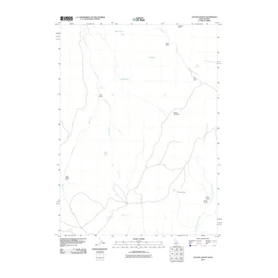
2010 Map of Taylor Canyon
USGS Topo · Published 2010About this map
Calhoun Butte anchors the northern reaches of this high-desert landscape along the Idaho-Nevada border. This area is defined by a network of seasonal water sources and landmarks that suggest a history of ranching and remote habitation. Evidence of early settlement is seen in structures like the Guy Kinyon Cabin near Cedar Creek and the Rutherford Cabin further south. The drainage patterns of House Creek, Taylor Creek, and the North Fork Salmon Falls Creek create a series of draws and canyons, including Jack Walker Draw and Timber Canyon. These watercourses are vital lifeblood in this environment, supporting localized areas such as Beaver Meadows and various watering holes like Merles Pond, Strawberry Spring, and Big Spring, which likely served as crucial points for travelers and livestock alike.
Find a feature on this map
24 named features on this map. Tap any name to fly to it.
Don’t see what you’re looking for? This feature index may not catch every label — zoom into the map to look around manually.
Map Details
Editions of this 2010 Taylor Canyon Map
This is the sole edition of this map. No revisions or reprints were ever made.
Other maps of this area

1955 · Twin Falls
USGS Topo · 1:250,000

1955 · Wells
USGS Topo · 1:250,000
1957 · Contact
USGS Topo · 1:62,500
1957 · Elk Mountain
USGS Topo · 1:62,500

1958 · Wells
USGS Topo · 1:250,000

1958 · Twin Falls
USGS Topo · 1:250,000

1961 · Wells
USGS Topo · 1:250,000
1977 · Browns Bench South
USGS Topo · 1:24,000
1977 · Cedar Creek Reservoir
USGS Topo · 1:24,000
1978 · Taylor Canyon
USGS Topo · 1:24,000