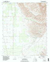
1992 Map of Tejon Hills
USGS Topo · Published 1995About this map
The Tejon Hills rise sharply from the San Joaquin Valley floor, defining a landscape shaped by petroleum extraction and livestock grazing. In the early 1990s, this area of Kern County was dominated by the El Tejon Field, where a network of wells and infrastructure like the Oil Sump and Water Tank supported the local Oil Field operations. The transition from the flat agricultural lands of the valley to the upland terrain is marked by the Grant Boundary, a legacy of early California land divisions. Seasonal drainages such as Tejon Creek, Tunis Creek, and El Paso Creek cut through the hills, while isolated water sources like Bino Springs and the Percolation Basin highlight the arid nature of the eastern valley edge. Significant landmarks like Comanche Point provide orientation across the varied topography of the ranch lands.
Find a feature on this map
22 named features on this map. Tap any name to fly to it.
Don’t see what you’re looking for? This feature index may not catch every label — zoom into the map to look around manually.
Map Details
Editions of this 1992 Tejon Hills Map
This is the sole edition of this map. No revisions or reprints were ever made.
Other maps of this area

1903 · Tejon
USGS Topo · 1:125,000

1914 · Caliente
USGS Topo · 1:125,000

1930 · Weed Patch
USGS Topo · 1:31,680

1930 · Bear Mountain
USGS Topo · 1:31,680

1930 · Arvin
USGS Topo · 1:31,680

1931 · West of Tejon Hills
USGS Topo · 1:31,680

1931 · Tejon Hills
USGS Topo · 1:31,680

1933 · Arvin
USGS Topo · 1:31,680
1933 · Weed Patch
USGS Topo · 1:31,680

1933 · Tejon Hills
USGS Topo · 1:31,680