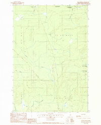
1988 Map of Telos Brook
USGS Topo · Published 1988About this map
Allagash Wilderness State Waterway defines the northern edge of this remote Maine landscape, where water drainage patterns dictate the region's character. The map centers on the intricate network of streams and brooks feeding into significant bodies like Telos Lake and the expansive Nesowadnehunk Lake. Historically tied to the logging industry and wilderness preservation, the area is crisscrossed by private roads and trails that navigate the townships of T 5 R 12 Wels and T 4 R 11 Wels. A localized industrial footprint is visible at the Shale Pit, providing a rare point of terrestrial excavation amidst the dominant hydrography of Telos Stream and Ripogenus Stream. The terrain is characterized by its numerous small tributaries, including Midnight Brook, Carlton Brook, and Cuxabexis Stream, which illustrate the complex watershed management of Piscataquis County.
Find a feature on this map
20 named features on this map. Tap any name to fly to it.
Don’t see what you’re looking for? This feature index may not catch every label — zoom into the map to look around manually.
Map Details
Editions of this 1988 Telos Brook Map
This is the sole edition of this map. No revisions or reprints were ever made.
Other maps of this area

1953 · Telos Lake
USGS Topo · 1:62,500

1954 · Chesuncook
USGS Topo · 1:62,500

1954 · Grant Farm
USGS Topo · 1:62,500

1954 · Harrington Lake
USGS Topo · 1:62,500

1954 · Presque Isle
USGS Topo · 1:250,000

1954 · Millinocket
USGS Topo · 1:250,000

1957 · Telos Lake
USGS Topo · 1:62,500

1958 · Presque Isle
USGS Topo · 1:250,000

1958 · Millinocket
USGS Topo · 1:250,000

1958 · Chesuncook
USGS Topo · 1:62,500