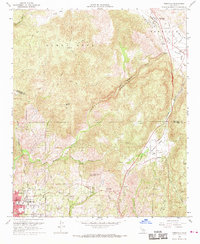
1968 Map of Temecula
USGS Topo · Published 1970About this map
Fallbrook anchors the southern portion of this 1968 revision, serving as a primary residential and agricultural hub where Stagecoach Lane and Mission Road converge. The landscape is defined by the steep descent of the Santa Margarita River as it carves through Temecula Canyon, a rugged corridor connecting the Temecula Valley to the coastal foothills. To the north, the small settlement of Temecula sits at the junction of Temecula Creek and the Temecula River, reflecting an era before modern suburban expansion. Local historical details include the Masonic Cem, the Vallecitos Sch in Rainbow, and the infrastructure of the San Diego Aqueduct. The map highlights the interplay between water management and varied terrain, from the heights of Gavilan Mtn to the orchards of Royal Oak Ranch.
Find a feature on this map
37 named features on this map. Tap any name to fly to it.
Don’t see what you’re looking for? This feature index may not catch every label — zoom into the map to look around manually.
Map Details
Editions of this 1968 Temecula Map
2 editions found
Other maps of this area

1901 · Southern California Sheet No. 1
USGS Topo · 1:250,000

1901 · Elsinore
USGS Topo · 1:125,000

1901 · San Luis Rey
USGS Topo · 1:125,000

1904 · Southern California Sheet No. 2
USGS Topo · 1:250,000

1904 · Southern California Sheet No. 1
USGS Topo · 1:250,000

1941 · Margarita Peak
USGS Topo · 1:62,500

1942 · Lake Elsinore
USGS Topo · 1:62,500

1942 · Margarita Peak
USGS Topo · 1:62,500

1942 · Temecula
USGS Topo · 1:62,500

1942 · Murrieta
USGS Topo · 1:62,500